As part of a panel titled ‘Questioning the Colonial: Three Counter Mapping Practices’ organised by Linda Knight we presented to an international audience very early in the morning (for us). The event was convened by the LivingMaps network as part of the series ‘Front Lines, Back Yards’.
LIVINGMAPS NETWORK WAS ESTABLISHED IN 2013 AS A NETWORK OF RESEARCHERS, COMMUNITY ACTIVISTS, ARTISTS AND OTHERS WITH A COMMON INTEREST IN THE USE OF MAPPING FOR SOCIAL CHANGE, PUBLIC ENGAGEMENT, CRITICAL DEBATE AND CREATIVE FORMS OF COMMUNITY CAMPAIGNING.
Our presentation was titled ‘Mapping Urban Plantiness’
In this presentation we introduce selected projects that seek to answer the question: how does our understanding of cultural, environmental, and social histories of place change if we let ourselves be guided by plants?
One of the methods we use to answer this question is to design plant-led maps. The first map we present (Marrickville Walks 2017) showcases a project on recombinant ecologies – or ecologies that are the result of human interactions, such as the case with cities in settler-colonial societies. We argue that in order to make recombinant ecologies present, as well as visible, we need a different order of maps, able to place the observer back in the thick of things, and to capture the entanglements between humans and more-than-human gatherings.
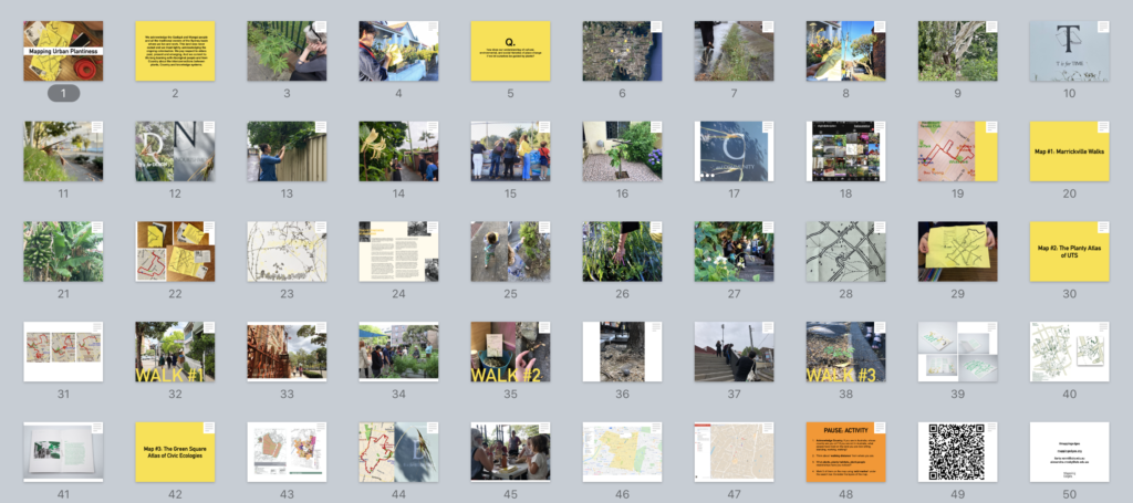
The second project (The Planty Atlas of UTS, 2019) maps a small inner city area around the university where we work, Ultimo. In this project we spotlight some of the historical and contemporary trajectories of this area starting from Gadigal Sydney, by following plants.
The third map is part of a work in progress (The Green Square Atlas of Civic Ecologies) that amplifies individual or organisations’ initiatives that bring together care for place and care for the environment in an area of large urban renewal in Sydney.
As part of the presentation, we invited audience members to contribute to a participatory map with a planty focus. Please try it!
You can get to the map through the QR code below, or this link
You need to be logged in to google to add markers. This is the link to Google how to work with My Maps: https://support.google.com/mymaps/?hl=en#topic=3188329.
1. Acknowledge Country. If you are in Australia, whose country are you on? If you are not in Australia, what people have lived on the land you are now on?
2. Think about ‘walking distance’ from where you are.
3. What plants, planty habitats, plant-people relationships have you noticed?
4. In the map choose a layer.
5. Mark it on the map (under the search bar, there is a little upside down tear drop, or you can write the address in the search bar
)
5. Name the marker
6. Play around to edit icons, colours, add pictures, descriptions… Look at Marrickville pin as an example.

0 Comments